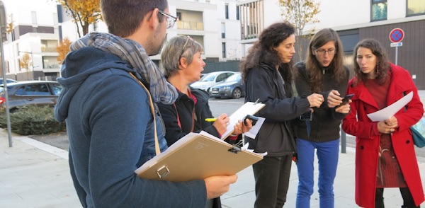
A certain number of local authorities propose to citizens to contribute to the knowledge of their territory: a way to co-construct the territory with the inhabitants and sometimes also to compensate for the erosion of budgetary resources. They rely, in particular, on OpenStreetMap. In addition to traditional information such as traffic routes, buildings or water surfaces, users can incorporate data such as bicycle paths, glass containers, public toilets or drinking water points into this collaborative map. Some communities (such as the Caux Vallée de Seine community or the Allier department) even organize workshops, based on the model of the carto-parties organized by OpenstreetMap communities, to gather a maximum amount of information on a given territory in a short period of time.
Collaborative mapping of cycling facilities in Île-de-France
Île-de-France Mobilités (formerly STIF, Syndicat des transports d'Île-de-France) undertook in 2017 to involve the people of Ile-de-France in the census of cycling facilities throughout the region. The most exhaustive knowledge possible (and of good quality) of these facilities and their updating aim to develop tools for route calculations while contributing to local policies in favor of cycling. In addition to local authorities, urban planning and development agencies and local bicycle stakeholders (such as the association Mieux se Déplacer à Bicyclette), this project relies on the OpenstreetMap community. It also relies on the contribution of people who can report directly in OpenstreetMap or via a dedicated portal, the various existing cycling facilities: cycle track, cycle lane, two-way cycle lane, bus lane open to bikes, parking lots. The Compagnie des Mobilités, together with Carto'Cité and the association Mieux se Déplacer à Bicyclette, is leading this campaign (a similar initiative was conducted in Lyon, La Ville à Vélo, but this time it was initiated by an association).City of Lannion: competitions to document the territory
After having used a paying application to establish the map of the city, Lannion decided in 2016 to switch to OpenStreetMap. To involve citizens, it has been organizing contests since then. In 2016, it had invited citizens to document the map on the theme of accessibility: nearly 1500 contributions had been recorded: pathways, street furniture, shops. The second edition, in 2017, focused on shops. The third edition in 2018 was on the theme of hiking and soft travel. Contributors were asked to complete the data in many areas: bike paths, trails, waterways, equestrian routes, points of interest on the trails (benches, signage, parking ...).Allier: participatory collection of geographic data at the scale of a department
The department of Allier has decided to call upon its inhabitants to build up a geographic database, rather than resorting to a service provider. To this end, it organizes carto-parties. Last March, residents were invited to indicate on the collaborative map of the department the presence of gas stations available in their area, as well as the presence of ATMs. 597 points were thus identified.Montpellier: the services of the metropolis collaborate with the OpenStreetMap community
As part of its OpenData approach, Montpellier Méditerranée Métropole has entered into a cooperation with the local OpenStreetMap community to update data related to the 31 municipalities of the metropolis. Montpellier Méditerranée Métropole shares best practices on the Montpellier page of the OpenStreetMap wikiLorient Agglomeration: a collaborative inventory of routes accessible to people with reduced mobility
Lorient Agglomération wanted to have a tool to monitor the progress of the various compliance works, to keep the list of establishments open to the public located on the territory up to date and to inform people with disabilities as best as possible of the degree of autonomy of their movements. The interactive map that has been set up includes all accessibility data (sections of road accessible to wheelchair users, intersections with audible indicators for the visually impaired, points of interest, establishments receiving the public, parks, transport stations and lines, parking spaces, events, tourist facilities, etc.). 25 referents (one per Lorient Agglomeration member municipality) contribute to the enrichment and updating of the facilities provided. In parallel with this geolocation application, Lorient Agglomération has developed a route calculator with the company Handimap, which maps accessibility according to the level of difficulty or type of disability.Collaborative mapping in the Seignanx for the promotion of tourism in the territory
The Seignanx Tourist Office (Landes) has undertaken to call upon local actors (municipalities, delegated services, tourist operators) and inhabitants to document the mapping of the territory. The project is based on OpenstreetMap and reuses existing data, such as tourism data, from the open database Sirtaqui. The project is financed by the New Aquitaine region and the Landes department, as part of a support to "Innovative Tourism" projects.Geolocation of works in progress in Villenave d'Ornon
The city of Villenave d'Ornon also relies on the use of OpenStreetMap to improve the information of its inhabitants. In a first phase, the project aims at providing information about the works in progress. This approach will be extended, in a second phase, to services (health, social) and cultural and sports facilities.Maine-et-Loire turns to Openstreetmap as an alternative to Google Maps
The new professional rates for Google Maps services came into effect last July. If individuals can continue to geolocate themselves for free with the services of the American firm, companies and communities that integrate Google Maps services to enhance their website or their application are subject to new rates. The limit of 25,000 maps per day has been raised to 28,000 per month, or just under 1,000 displays per day. At the same time, the rate of $0.5 per 1,000 posted cards was increased to $7. A site that posts 10,000 cards per day goes from $0 to $1,764 per month, and a site with 100,000 cards posted per day sees its cost multiplied by more than 500. These additional costs are difficult for local governments to absorb. Alternatives include the use of the IGN's Geoportal APIs or the extensions offered by geographic information system (GIS) publishers.The department of Maine-et-Loire (whose website has 200,000 visitors each month and which integrates mapping services: road traffic, map of nature trails, directory of institutions for the disabled, map to find out which college you belong to or to find childcare assistants) has undertaken, for its website, to base all of its maps on OpenStreetMap, "in order to continue to offer a quality service at the best possible cost.
Références :
Sources
- 1. For a better knowledge of cycling facilities in Île-de-France
- 2. City of Lannion, Côtes d'Armor: Using OpenStreetMap for public services
- 3. The Allier launches into participatory geographic data collection
- 4. Lorient Agglomération: a route planner for people with reduced mobility
- 5. Map of the Seignanx territory
- 6. Maine-et-Loire finds an open source alternative to Google Maps
- 7. Google Maps price hike: "We need free alternatives more than ever
- 8. Gilles Palsky : participative cartography, undisciplined cartography


